
STARCHARTS AND STELLAR NAVIGATION
Galactic Information
The Milky Way Galaxy is divided into four large quadrants, each quadrant containing approximately 10,000 sectors grouped into sector-quads of 1000 sector each. Sectors may be either named numerical (i.e. "Sector 123" or by relevant stellar bodies in the region ("Taurus Sector")


SECTOR

QUAD
Stellar Navigation
Navigation in space is accomplished by one of three methods: Mark Bearing, Setting Course, and charting by Galactic coordinates. Mark bearing navigation is normally utilized when charting unexplored space, while setting a course is the standard method of navigating known space lanes. Charting courses by galactic coordinates is normally only used by spacecraft with smaller crews and is entirely dependent on access to complete star charts.
Bearing Navigation

Course is charted relative to the spacecraft with bearing 000 being the current orientation and the course marked on an azimuth angle. An elevation (mark course) is used for vertical course charting. A 360 or a more precise 1000 angle system may be used for plotting
Course Navigation

The ship's course is charted relative to the center of the galaxy, with course 000 orientating towards galactic center. An elevation (mark course) is also utilized. All courses charted using a standard 360 degree orientation
Galactic Coordinates

Charting by Galactic coordinates is only possible with a complete set of starcharts for use by the ship's navigation computer. Courses are input by x,y,z coordinates (ex: 012 by 415 by 357) on a 1000 point scale.
STARCHARTS
UESPA Starcharts

Chart 1-1: Sol System

Chart 1-3: Earth Spacelanes

Chart 1-2: Earth Orbit

Chart 1-4: Outer Sector 001
Earth Cargo Service Charts

Chart 2-1: Sector 001
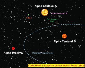
Chart 2-3: Alpha Centauri

Chart 2-2: Earth Approaches
Vulcan Starcharts

Chart V-1: Vulcan Space Lanes

Chart V-2: Triangula Trade Route